How Do Glaciers Move and Shape Land
In this post
A glacier looks like the least mobile thing on Earth: a river of ice, frozen in place, silent and still. Yet glaciers move, sometimes only centimetres a day, sometimes metres, and over thousands of years that slow movement reshapes entire landscapes. It carves valleys, scrapes mountainsides, transports boulders the size of houses, and leaves behind lakes, hills, and ridges that remain long after the ice has gone. Much of the scenery we admire in places like Norway, Scotland, New Zealand, and the Alps was made by ice, not by rivers or wind.
This guide explains how glaciers move, why solid ice can flow like a very slow liquid, and how that movement sculpts the land beneath and around it. It also looks at what happens when glaciers retreat, and why their meltwater matters far beyond the mountains where they sit.
What a glacier actually is
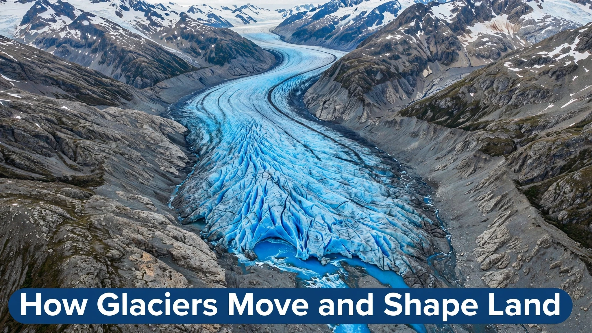
A glacier is a large, persistent body of ice that forms where snow accumulates faster than it melts, year after year. Fresh snow is light and full of air, but as more snow falls on top, the weight compresses the layers below. Air is squeezed out, snow grains fuse, and over decades the snow turns first into dense firn and then into solid glacier ice, which is blue rather than white because its crystals absorb red light and scatter blue.
For a glacier to exist, it needs a balance: more snow added in its upper region, called the accumulation zone, than is lost by melting and breaking off in its lower region, called the ablation zone. The line between them is the equilibrium line, which moves up or down with climate. If accumulation exceeds loss over many years, the glacier advances. If loss exceeds accumulation, it retreats, even though the ice itself is still flowing forward. That distinction confuses many people: a retreating glacier is not flowing backwards; it is melting at its front faster than new ice arrives.
Glaciers come in several forms. Mountain or valley glaciers flow down valleys like frozen rivers. Ice caps cover smaller mountain areas, while ice sheets, in Greenland and Antarctica, cover whole continents and are kilometres thick. Tidewater glaciers end in the sea, where chunks break off as icebergs in a process called calving. Despite their different sizes, all glaciers share the same basic physics: gravity pulls ice downhill, and ice, under enough pressure, deforms and flows.
How solid ice can flow
Ice seems brittle when you drop an ice cube, but under the weight of a glacier, it behaves differently. Deep inside a thick glacier, pressure is enormous, and ice crystals slowly slide past each other and recrystallise, allowing the ice to deform like a very thick, slow fluid. This internal deformation is one of two main ways glaciers move. The other is basal sliding, where the glacier slides over the rock beneath it, helped by a thin layer of meltwater that acts as a lubricant.
Which mechanism dominates depends on temperature and conditions at the base. In warm-based glaciers, where the base is at melting point, water is present and sliding can be significant, making the glacier move faster. In cold-based glaciers, frozen to the bedrock, movement is mainly by internal deformation and is much slower. Some glaciers also move in sudden surges, advancing rapidly for months or a few years, then slowing again, often because meltwater builds up underneath and reduces friction. Surge behaviour is still studied, because it can be dramatic and hard to predict.
Speeds vary enormously. Many valley glaciers move only a few centimetres to a few tens of metres per year. Some fast outlet glaciers in Greenland and Antarctica move several kilometres per year, carrying vast amounts of ice to the sea. The centre of a glacier usually moves faster than its edges, where friction with valley walls slows it, and the surface moves faster than the base, creating a curved flow pattern that can be seen in the bending of debris bands and crevasses on the ice surface.
Erosion: the glacier as a giant rasp
As a glacier moves, it erodes the land beneath it in two main ways. The first is abrasion: rocks and grit frozen into the base of the ice act like sandpaper, grinding and polishing the bedrock as the glacier slides over it. This produces smooth, rounded rock surfaces, fine rock flour that turns meltwater milky blue-green, and long scratches called striations that record the direction of ice flow long after the glacier has gone.
The second is plucking, sometimes called quarrying. Meltwater seeps into cracks in the bedrock, freezes, expands, and wedges blocks loose. As the glacier moves, it picks up those blocks and carries them away, leaving jagged, broken rock faces on the downstream side of obstacles. Together, abrasion and plucking can remove enormous volumes of rock. Over thousands of years, a glacier can deepen a valley by hundreds of metres, widen it, and straighten its course, overpowering the original river valley beneath it.
Glaciers also transport material. Rocks that fall onto the ice from valley walls, or are plucked from the bed, are carried along like cargo on a conveyor belt. Some of this debris ends up in ridges along the sides and front of the glacier, called moraines. Lateral moraines form along the edges, medial moraines where two glaciers join, and terminal moraines where the glacier front deposits its load as it melts. When the ice retreats, these ridges remain as clear evidence of where the glacier once stood, and large boulders left far from their source rock, called erratics, can be traced back to their origin kilometres away.
Valleys, fjords, lakes, and other glacial landforms
The most recognisable glacial landform is the U-shaped valley. A river carves a narrow V-shaped valley, but a glacier, being much wider and more powerful, erodes both the floor and the sides, producing a broad, flat-floored valley with steep sides. When the ice melts, that shape remains, and it is one of the easiest ways to recognise a landscape once shaped by glaciers, from the Scottish Highlands to the valleys of the Alps and the Rockies.
Where a glacier reaches the sea, it can carve a fjord: a deep, steep-sided inlet flooded by seawater after the ice retreats. Norway’s fjords are the classic example, some more than a kilometre deep, with cliffs rising directly from the water. Smaller tributary valleys, left hanging high above the main valley floor because the main glacier eroded more deeply, become hanging valleys, often with waterfalls plunging from their lips.
Glaciers also create lakes in several ways. Ice can dam a valley, trapping meltwater behind it. A depression gouged by ice can fill with water after retreat, forming a tarn or a larger lake. And moraine dams can hold back water, sometimes unstably, creating a risk of sudden outburst floods if the dam fails. Cirques, bowl-shaped hollows carved at the head of a glacier, often hold small lakes after the ice goes, and are a favourite feature of mountain walkers, who may not realise they are standing in a bowl scooped out by ice.
Other landforms include drumlins, smooth elongated hills shaped by ice moving over soft sediment, and eskers, winding ridges of sand and gravel deposited by meltwater streams flowing under or within the ice. Together, these features form a kind of fingerprint: a trained eye can read a landscape and reconstruct where ice flowed, how thick it was, and in which direction it moved, centuries or millennia after it vanished.
Life, water, and people downstream
Glaciers are not just scenery; they are water stores. In many mountain regions, glacial meltwater feeds rivers during dry summer months, when rain is scarce and snow has already melted. Farmers, towns, and hydroelectric plants downstream depend on that steady summer flow. In parts of Asia, South America, and the Alps, millions of people rely, directly or indirectly, on rivers fed by glaciers, and the timing of meltwater can matter as much as its total amount.
Glacial meltwater also carries rock flour, fine sediment that gives some lakes and rivers their striking turquoise colour. That sediment affects aquatic life, sometimes limiting light for plants, sometimes supplying minerals. As glaciers retreat, new land is exposed, and plants, insects, and birds colonise it in a sequence ecologists study closely: first lichens and mosses, then grasses and shrubs, then, over decades, trees. A retreating glacier therefore creates a living laboratory for how ecosystems assemble from bare rock.
For people, glaciers also bring hazards. Crevasses, hidden cracks in the ice, are dangerous for climbers. Icefalls, where a glacier tumbles over a steep step, can collapse without warning. Glacial lake outburst floods, when a moraine dam or ice dam fails, can send a wall of water and debris down a valley with little warning. As glaciers thin and retreat, these hazards change: new lakes form, old routes become unstable, and communities downstream must adapt to a landscape that is still adjusting to the loss of ice.
Glaciers in a warming world
Most glaciers worldwide are now retreating, and the cause is well established: rising temperatures increase melting and reduce snowfall in many regions, shifting the balance so that loss exceeds accumulation. Satellite measurements, repeat photography, and field surveys all show the same pattern: glacier fronts pulling back, ice thinning, and in some places small glaciers disappearing entirely. Iconic comparisons, such as photographs of the same Alpine or Rocky Mountain glacier taken a century apart, make the change visible to anyone, without needing a graph.
The consequences reach far beyond the mountains. Meltwater from glaciers and ice sheets contributes to sea level rise, together with the expansion of warming seawater. The contribution from mountain glaciers alone is significant, and Greenland and Antarctica add far more. For coastal cities, even a few centimetres of sea level rise increases the risk from storm surges and high tides. For mountain communities, glacier loss threatens summer water supplies, increases the risk of outburst floods from new lakes, and changes tourism, as famous ice features shrink or vanish.
There is also a feedback effect: as bright ice and snow retreat, darker rock and water are exposed, which absorb more sunlight and warm further, accelerating melting. This is one reason glacier loss can continue even if temperatures stabilise, because the landscape itself has changed. Scientists are careful to note that individual glaciers respond differently, depending on local snowfall, shading, debris cover, and topography, and some glaciers in very snowy regions may advance temporarily. The overall global trend, however, is clear, and it is one of the most visible signs of a warming climate.
Reading a landscape after the ice has gone
Long after a glacier melts, a careful walker can still read where it went, because ice leaves clues that rivers and wind rarely produce. One of the clearest is a striation: a long, straight scratch carved into bedrock by grit frozen into the glacier’s base. Striations on a single rock face usually run parallel, recording the direction of ice flow as faithfully as a compass needle records north. Where striations cross at different angles, they can reveal that ice flowed in one direction during an earlier glaciation and in another direction during a later one, giving geologists a layered history from a single outcrop.
Another clue is the erratic, a boulder whose rock type does not match the local geology. An erratic may sit alone in a field, perched on a hillside, or balanced improbably on other rocks, having been carried by ice from a source kilometres or even hundreds of kilometres away. By identifying the source rock, geologists can trace the path of the vanished glacier almost as if it had left a forwarding address. Some erratics are so large and so far from home that early observers, before glacier theory was accepted, struggled to explain them at all, and some suggested they had been carried by floods or even by icebergs in an ancient sea.
Dating these clues has become increasingly precise. Scientists can measure how long a rock surface has been exposed to cosmic rays since the ice left it, a technique called cosmogenic dating, or study the layers of sediment in a nearby lake for the moment when glacial silt gives way to organic material. Together, these methods allow researchers to reconstruct not just where ice was, but when it arrived and when it left, valley by valley. That reconstruction matters for the present, because landscapes still adjusting to the loss of ice, with rivers cutting new channels, slopes becoming unstable, and lakes forming behind fresh moraines, behave differently from landscapes that have been ice-free for ten thousand years. Reading the past, in other words, is also a way of predicting which valleys are most likely to change next.
My Take:
My first judgement is that glaciers deserve to be taught as builders, not just as frozen scenery. We tend to picture erosion as something rivers and rain do, slowly, over ages, while ice sits still. The truth is almost the opposite: ice is one of the most powerful sculptors on Earth, capable of deepening a valley by hundreds of metres, carrying house-sized boulders for kilometres, and leaving a landscape that rivers then merely tidy up. When you stand in a U-shaped valley or look at a fjord, you are not looking at a river’s work. You are looking at a glacier’s signature, written in rock, long after the author has gone.
My second judgement concerns the confusion between a glacier moving and a glacier retreating, because that confusion is used, sometimes innocently and sometimes deliberately, to downplay glacier loss. A retreating glacier is still flowing forward; it is simply melting at its front faster than ice arrives from behind. Saying “the glacier is still moving, so it is fine” is like saying a bank account is fine because money is still being paid in, while ignoring that far more is being withdrawn. The correct measure is the balance: accumulation versus loss over years. On that measure, most glaciers today are losing, and the photographs that show fronts pulling back year after year are not tricks of perspective.
I also think the human story downstream deserves more attention than the postcard view upstream. Tourists photograph a glacier’s front, but farmers hundreds of kilometres away depend on its summer meltwater, and coastal residents depend, indirectly, on how much ice stays locked on land rather than flowing to the sea. Glacier science is therefore not remote mountain science; it is water science, food science, and coastal safety science. When a glacier shrinks, the effects ripple outward through rivers, reservoirs, and sea levels, reaching people who may never see ice in their lives.
A further point is about time. Glaciers work on timescales that human planning struggles with. A valley carved over ten thousand years, a moraine built over centuries, a lake that forms in a decade and then bursts in an afternoon: these are not events that fit neatly into a five-year plan or a news cycle. I think that mismatch explains why glacier change is easy to ignore until it becomes a flood, a water shortage, or a vanished tourist attraction. Learning to think on glacial timescales, where slow movement produces sudden consequences, is a skill our institutions badly need.
I would also push back against the idea that glacier retreat is only a loss to be mourned. It is a loss, for water supplies, for ecosystems, and for landscapes, but retreat also creates new land, new lakes, and new scientific opportunities. Ecologists can watch life colonise bare rock in real time. Geologists can read freshly exposed surfaces that were hidden for centuries. Local communities can, with care, develop new routes, new habitats, and new ways of living with a changing mountain. Mourning alone is passive; studying and adapting to the new landscape is active, and it is the more useful response.
Finally, my practical takeaway is to look for glacial fingerprints wherever you travel in hilly country. A flat-floored valley with steep sides, a lone boulder that does not match the local rock, a ridge of gravel across a valley floor, a lake sitting in a bowl at the head of a valley: each is a clue that ice once stood where you stand. Reading those clues turns a walk into a history lesson written in stone, and it makes the abstract idea of climate change concrete. The ice that shaped that valley is retreating now, in our lifetimes, and the land it leaves behind will be the inheritance of the next generation. Whether that inheritance is managed wisely depends on whether we understand what the ice did, and what its loss means.
There is also a measurement problem that I think the public underestimates. We talk about glaciers retreating as if it were a single number, but a glacier’s health is measured in many ways: front position, thickness, surface speed, mass balance, and the volume of meltwater it releases. A glacier can retreat at its front while thickening upstream, or thin in its middle while its front stays put, held in place by a narrow valley. Good reporting therefore looks at several measures together, over years, rather than seizing on one dramatic photograph. The overall picture from all those measures is still one of loss, but the details matter for local water planning, and they deserve more attention than a single before-and-after image.
I would add a judgement about debris-covered glaciers, which complicate the simple story that melting ice is always visible. In some mountain ranges, a thick layer of rock debris insulates the ice beneath, slowing surface melting while the glacier still thins from below or at its edges. Such glaciers can look like ordinary rocky valleys, with only a careful eye noticing ice beneath the stones, meltwater streams emerging from debris, or ponds forming and draining. Ignoring them because they do not look like postcard glaciers would underestimate both the ice still present and the hazards it can create, including sudden lake drainage. Appearance, in glaciology as in other fields, is a poor substitute for measurement.
Finally, I think glacier loss should change how we teach geography itself. Too often, landscapes are presented as finished: here is a valley, here is a lake, here is a coastline, as if they had always been that way. Glacial landscapes are a perfect counter-example, because they are visibly unfinished, still rebounding, still eroding, still adjusting to ice that left thousands of years ago in some places and is leaving now in others. Teaching that unfinished quality, the idea that the ground beneath our feet is still moving, even if slowly, would make climate change less abstract. It is not only about future temperatures; it is about a landscape in motion, recorded in striations, erratics, and moraines, and still being rewritten by the ice that remains.
Frequently Asked Questions
Do glaciers move if they look frozen solid? Yes. Under their own weight, ice deforms slowly and can also slide over rock on a thin layer of meltwater. Many glaciers move centimetres to metres per day, even though the movement is invisible to the eye.
What is the difference between a glacier advancing and retreating? A glacier always flows forward downhill. It advances when accumulation exceeds melting, so its front moves forward, and retreats when melting exceeds accumulation, so its front moves back even though ice still flows forward.
How does a glacier make a U-shaped valley? A glacier erodes both the floor and sides of a valley through abrasion and plucking, widening and deepening it into a broad, flat-floored valley with steep sides, unlike the narrow V-shape carved by a river.
What is a moraine? A moraine is a ridge of rock debris deposited by a glacier. Lateral moraines form along its sides, medial moraines where two glaciers join, and terminal moraines at its front where melting deposits its load.
What is a fjord? A fjord is a deep, steep-sided coastal inlet carved by a glacier and flooded by the sea after the ice retreats. Norway’s fjords are among the most famous examples.
Why does glacier melting raise sea level? Meltwater from land-based glaciers and ice sheets flows into the oceans, adding water, while warming seawater also expands. Both effects raise global sea level and increase coastal flood risk.